

Kananaskis Peaks & Trails app for iPhone and iPad
Developer: Mountain Apps Inc.
First release : 18 Jun 2011
App size: 190.24 Mb
A complete guide to the peaks and trails of Kananaskis Country, featuring a detailed hiking guide for the most popular day hikes, and introductions to more than 85 trailheads.
Exclusive content from two respected Canadian Rockies authors: Gillean Daffern, author and publisher of numerous trail guides (more than 100,000 copies sold) and Dave Birrell, author of www.peakfinder.com and Accredited ‘Professional Interpretor’ by the Interpretive Guides Association.
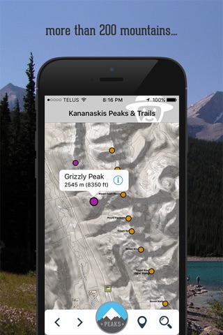
--For each of the over 200 mountains in Kananaskis Country, the app provides photos, its naming history, and other information related to its geology, geographical context, historical significance, and stories of what has happened on the mountain -in many cases connecting interesting historical figures with the individual peaks.
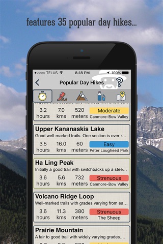
--For 35 popular day hikes in Kananaskis Country, the app includes detailed maps and hiking instructions. These hikes offer a wide range of choices, from easy, short day walks to long ridgewalks―with a pitch or two of easy scrambling. There is something here for everyone.
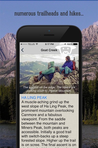
--For all 85 trailheads in Kananaskis Country, the app presents an introduction to the hikes that can be accessed and photos of what you might see on the hike.
Identify and learn about the peaks as you drive through Kananaskis Country, even if you’re not going hiking.
FEATURES:
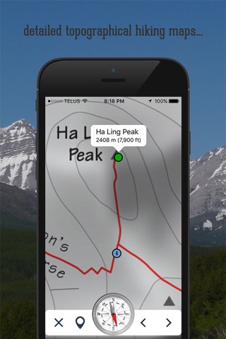
--High-quality topo maps provide background for the peaks, featured popular day hikes, and trailheads.
--Your GPS location, on the road or on the trail.
--Over 500 beautiful photos illustrate the peaks and trails.
--Includes an introduction to the geography, geology, and history of the Canadian Rockies.
--Requires no “network” or “wifi” connection for full functionality. All information, maps, and photographs are integrated into the app itself. GPS does not require a data connection.
THE AUTHORS
Gillean Daffern has explored Kananaskis Country for decades and understands its landscape and history intimately throughout every season of the year. She has also been writing and publishing bestselling trail guides to Kananaskis Country for over 30 years and is the author of the renowned five-volume series Gillean Daffern’s Kananaskis Country Trail Guide. Gillean is the founder of Rocky Mountain Books and, along with her husband, Tony Daffern, was awarded the Banff Mountain Festival’s Summit of Excellence Award in 2006.
Dave Birrell is a geophysicist, teacher, and the author of three books regarding the Canadian Rockies as well as www.peakfinder.com, a website that provides detailed information on over 1,550 peaks. Dave has travelled extensively throughout the Canadian Rockies on foot, skis, and horseback. Accredited as a "Professional Interpreter" by the Interpretive Guides Association, he has guided hiking and bus tours in the mountains. Dave provides content for a number of apps regarding the Canadian Rockies.
WHAT’S NEW
--Detailed trail descriptions for 35 Popular Day Hikes, by Gillean Daffern
CANMORE-BOW VALLEY
Grassi Lakes
Ha Lin Peak
Teahouse Ridge
Grotto Canyon
Raven’s End
Bow Valley Park Loop
Heart Mountain Circuit
Wind Ridge
KANANASKIS VALLEY
Barrier Lake Lookout
Centennial Ridge of Mt. Allan
Ribbon Falls
Lillian Lake
PETER LOUGHEED PROVINCIAL PARK
Upper Kananaskis Lake
Rawson Lake
Indefatigable Trail
Ptarmigan Cirque
Pocaterra Tarn
THE SMITH-DORRIEN
South Buller Pass
Burstall Pass
Chester Lake
Headwall Lakes
THE HIGHWOOD
Mist Ridge
Picklejar Lakes
Mount Burke
Grass Pass
THE SHEEP
Foran Grade Loop
Volcano ridge Loop
THE ELBOW
Elbow Valley-Riverview Loop
Moose Mountain
Prairie Mountain
Powderface Ridge
Nihahi Ridge
Forgetmenot Ridge
THE JUMPINGPOUND
Jumpingpound Mountain
Cox Hill